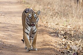
Tadoba" is taken from the name of the god "Tadoba" or "Taru", worshipped by the tribes who live in the dense forests of the Tadoba and Andhari region, while "Andhari" refers to the Andhari river that meanders through the forest.
Legend holds that Taru was a village chief who was killed in a mythological encounter with a tiger. Taru was deified and a shrine dedicated to Taru now exists beneath a large tree on the banks of Tadoba Lake. The temple is frequented by adivasis, especially during a fair held annually in the Hindu month of Pausha (December–January).
The Gond kings once ruled these forests in the vicinity of the Chimur hills. Hunting was banned in 1935. Two decades later, in 1955, 116.54 square kilometres (45.00 sq mi) of this forest area was declared a national park. Andhari Wildlife Sanctuary was created in the adjacent forests in 1986. In 1995, the park and the sanctuary were merged to establish the present tiger reserve.
Tadoba Andhari Reserve is the largest national park in Maharashtra. The total area of the reserve is 625.4 square kilometres (241.5 sq mi). This includes Tadoba National Park, with an area of 116.55 square kilometres (45.00 sq mi) and Andhari Wildlife Sanctuary with an area of 508.85 square kilometres (196.47 sq mi). The reserve also includes 32.51 square kilometres (12.55 sq mi) of protected forest and 14.93 square kilometres (5.76 sq mi) of uncategorised land.
To the southwest is the 120 hectares (300 acres) Tadoba Lake which acts as a buffer between the park's forest and the extensive farmland which extends up to Irai water reservoir. This lake is a perennial water source which offers a good habitat for Muggar crocodiles to thrive. Other wetland areas within the reserve include Kolsa Lake and the Andhari River.
Tadoba Reserve covers the Chimur Hills, and the Andhari sanctuary covers the Moharli and Kolsa ranges. It is bounded on the northern and western sides by densely forested hills. Thick forests are relieved by smooth meadows and deep valleys as the terrain slopes from north to south. Cliffs, talus, and caves provide refuge for several animals. The two forested rectangles are formed of the Tadoba and Andhari ranges. The south part of the park is less hilly than the remainder.


Post a Comment